
The problem
The urgency of spatial plans can be readily explained. Simply stated, it consists of the following: The economic problems of Bangladesh have no parallel anywhere. Iowa and Illinois each have the same land area as Bangladesh but as to people? Iowa has only 3 million while Illinois has 12 million —Bangladesh has about 180 million! The really scarce physical resource is land—how can its allocation not be a primary concern?
Neither environment, nor industry, nor housing, nor transportation will function smoothly unless space is made an integral part of all Government of Bangladesh (GoB) activity. That is the point of this article. I begin with an informal statement of issues, and then make a more formal one about the type of process that should be introduced.
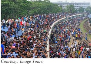 When I explain the economic situation of Bangladesh to Americans, they stare blankly. Nothing in their experience (or anyone else’s) has prepared them to imagine such a thing. When an American saw a picture of crowds going home for Eid by train, he looked at the people —hanging on the sides, inside and above the compartment— and asked ‘Where is the train?’ One has to be willing to think about the economic problems of such a country anew, ab initio.
Space affects everything
To elaborate upon the reasons why spatial planning is so important let me give a bird’s-eye view of the situation facing a Bangladeshi economist. The overarching goal is economic growth in the future and palpable progress now. The old formula ‘suffer and grow, then redistribute’ has faded away. Unless people can aspire to a better life and see it within their grasp, people will be frustrated and angry. This despair over jobs and incomes laid the seeds of the opposition to the fallen autocracy.
Nor was it unreasonable. Indeed, the promise of independence included liberty as well as an end to the grinding poverty of millions. But while all agree that such desirable economic growth is needed, only a few recognise all the factors that constrain the achievement of this goal. Let me list the most prominent of these constraints:
- Population
- Food
- Housing
- Education
- Urbanization
- Transportation
- Women empowerment
- Environment
- Water, especially Floods
- Power, Electricity & Gas
- Running water & Sanitation
Each item above is important and each needs space (or land). When so many critical factors jostle each other for their share of scarce, indispensable land, conflicts must arise unless some overarching body or principle guides the process. We would not place ten persons in a room with a jug of water and expect them to drink the water without having fights – if we just left it to the individuals. Why should it be otherwise with land? There is the additional complication with land that the fulfilment of different spatial needs is not independent of each other, but can be interdependent.
The direct need
Let me discuss the cases first where the land scarcity is obvious, such as agriculture, floods & housing, and then Illustrate with those issues where this is not obvious such as family planning, drinking water, fuel and electricity.
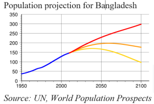
 The 180 million are likely to grow to 210-220 million before levelling out. It may grow more unless birth control is made more effective. Right now, about half the population consists of those under 20. Their requirements, nay demands, for both food and housing will grow as the population becomes full of mature adults. Housing requires space and food, meaning rice in Bangladesh, even more so. Land that is good for housing, typically high land, may be even more valuable for agriculture. Unless both uses are simultaneously considered, conflicting claims will arise. An obvious solution is to combine planning for both together since each component takes up space.
But simply growing more food is not going to generate economic growth. Either we move towards rice exports, in which case land for export-rice becomes especially valuable and in need of planning, or we move towards non-traditional high value (NTHV) agriculture, items like spices or fruits or flowers. At this moment, we simply lack the superposed maps of soil, climate and potential crops even to know which lands will have the highest value for NTHV crops. If all the land is not mapped out and the space allocated by best use, too much may be lost.
Indirect need
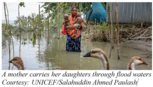 Even when the connection is indirect, spatial planning is important. Consider floods. If you think of containing the floods through embankments or dams, then these obviously require some land, but that is not the major issue. If these plans are successful then people will feel free to build homes and cultivate land within the embankment protected areas.
This is what has happened. The silt that was transported by the rivers and deposited on the rice fields by flood waters now stays in the river. As the river beds get silted, the river rises, and threatens even higher floods, going above the embankment. That is the situation today. If we remove the embankment, then the obvious loss is to agriculture and housing. But since the rivers will now replenish the fertility of the land, one year’s loss is compensated by the next year’s gain. Furthermore, a plentiful supply of riverine fish comes in with the flood. So, the lasting damage is to housing and industry as comparatively few lives are lost due to floods. Why not embank the houses?
But rural houses are already built on such ‘embanked’ land. So, one solution to floods is to have industry and infrastructure on embanked land. We began with floods and food, and we end up seeing housing and rural industrial settlements being suggested by the analysis. Since such effects are foreseeable, we cannot decide one without the other.
Finally, consider family planning. Bangladesh was once enormously successful in reducing its fertility rate. The most effective part of the family planning programme, inducing women to have fewer pregnancies, consisted of house-to-house visits by family planning workers. If our population continues to live in dispersed housing, the costs of such house-to-house visits can become prohibitive. Indeed, this is one of the reasons why the program has been discontinued. But if rural houses are clustered together in settlements, then 20 houses can be served by a single family-planning advisor. This makes the programme expense affordable.
An equally significant effect of such rural settlements, with long run implications, is the ease of regular interaction that women can have with each other. The women are no longer necessarily conversing with their family members, or their elders, where they are constrained by multiple social ties, but as independent women who can exert agency. So, the pattern of rural housing has significant implications for both family planning and for female empowerment over time.
To summarize, events take place in space and time. Yet planning in Bangladesh has proceeded without explicit regard to the spatial nature of actions. Two costly examples to illustrate the problem are, first, the Sayedabad water treatment project and secondly, the incongruity of Road and Rail in the transport sector plans. I have not detailed these to avoid technical issues.
How to proceed
Let me now restate the issues somewhat more formally, in an actionable sense, so that the bureaucratic procedures needed for systematizing spatial planning are introduced. The remainder of this section is adapted from a paper written by the Bangladesh Institute of Planners (whom I also advised on this matter).
In Bangladesh, public sector plans, big or small, are implemented as projects. Therefore, the ultimate quality of public investment depends on properly translating aggregate socio-economic plans to projects in geographic space. This translation is done by line ministries or departments through sectoral masterplan or even through direct project design by sectors. This process can instil incoherence in project planning across sectors, which leads to overlap, conflict, and lack of coordination during implementation.
Spatial planning is proposed as a bridge between national socio-economic plans and ground-level projects through a three-tier spatial planning system covering all Bangladesh, supported by legal and institutional mechanisms as needed. Without such a planning system, currently 90 per cent of the country’s land area is outside any form of spatial plan. This has led to large-scale sprawl and massive loss of land away from agricultural production in rural areas. If we examine just the remit of one ministry, the Environmental ministry, we see that the above has been endangering the ecology and natural habitat that support wildlife and biodiversity.
The Government of Bangladesh, through the Ministry of Environment, Forest and Climate Change (MoEFCC), has committed itself to ‘Spatial Planning for All Areas’, as the first target, and submitted it to the UN Convention on Biological Diversity (CBD) Secretariat. However, implementing this commitment to Spatial Planning requires contributions from The Ministry of Housing and Public Works, Ministry of Local Government, Rural Development and Cooperatives, Ministry of Land and all other ministries delivering the development agenda of GoB. The current bifurcated approach to planning through line ministries clashes with the comprehensive approach implied by the importance given by CBD to involving the ‘whole of the government’.
Since comprehensive trans-sectoral plans cannot be steered by any single sectoral ministry, spatial plans will be one of the instruments employed by the Planning Ministry. In the short run, all projects will be required to provide a Spatial Planning Impact Assessment (SPIA) to ensure the conformity of any development project with the local Spatial Plan or in the absence of any such plan, ensure spatial congruity. More effective administrative integration can then be on the agenda. To endow appropriate authority, the National Economic Council might be renamed as the National Spatial Planning and Economic Council (NSPEC). More effective administrative integration can then be on the agenda. This outline provides the modality for making spatial planning an effective component of any decision regarding the economy, since spatial concerns affect virtually everything, land being the most scarce resource in Bangladesh.
Conclusion
Spatial planning is only one of many desirable features of a well-functioning administration, but it is an essential one. It is a vital tool, not a policy. There are currently basic reforms being completed in banking, judiciary and law. If they all succeed, then the bureaucracy will be well behaved, the legal system adjusted, the police dutiful, and so on. We have a finely tuned machine; but what should we make it do? Which direction should the economy go? These are not the questions that spatial planning can answer.
But, no matter which path is chosen, the need for land will not disappear. Participation of the private sector in policy discussions is essential, as is transparency in economic data. Frequent, patient and persistent exchanges on economic issues are vital to engage the public. Precisely because land is so scarce, policies about land allocation should be widely discussed. In the desirable allocation of land under any growth path, space will be vital. Hence the necessity of making spatial planning integral to the planning process.

Salim Rashid
Salim Rashid, Emeritus Professor of Economics, University of Illinois, Urbana-Champaign. He did his B Sc from the London School of Economics and PhD from Yale University. Professor Rashid’s main interests are: development economics, economic theory, religion and economics. He has published many articles, written five books and edited four volumes. For the last thirty years he has been working on the economic problems of Bangladesh. He has been a consultant for international organizations, such as the World Bank and the Asian Development Bank. He is currently one of the editors of the Journal of Asia Pacific Economy and the past President of the Association for Economic and Development Studies on Bangladesh.

