
When I came to the US as a graduate student of Geology in the early 1980s, our freshman orientation class in State University of New York (SUNY) at Stony Brook was not conducted in an auditorium. Instead, it was done in a field trip to the Catskill Mountains where professors introduced us to various facets of geology of the northeast US. We all slept in our sleeping bags under the stars on an outcrop of rocks, polished and smoothed, as if for our sleeping comfort by glaciers of past ice ages!
That was the beginning of my many field trips and road trips across America, sometimes with professional or academic groups, often alone, and sometimes with friends or family. America is a great country for road trips. There are 4 million miles of excellent roads and highways in the US connecting countless big and small cities, 63 National Parks, 63 Historical Parks, 131 National Monuments, 6,792 State Parks and many other places of interest. For roadside lodging, you have motels and hotels, public and private campgrounds, Bed and Breakfasts, and more recently, Airbnbs nearly everywhere. And thanks to GPS, smartphones and the Internet you can get a running commentary of your progress toward the destination unlike the old days when I had to rely on folded maps with my route highlighted by AAA officials. Road trips are becoming easier and more popular all the time.
In May, 2023, my wife, son and I embarked on a carefully planned nine-days road trip that would take us from Dallas, Texas to selected sites of American South-West spread across the states of Colorado, Utah, Arizona and New Mexico (Photo 1). These states are not only known for their exceptional natural beauty, but also for Native American history and culture. Due to limited space, I will describe the visited sites very briefly with only one photo each.
Day 1: Drive from Dallas, Texas to Colorado Springs, Colorado
This was our longest one-day drive in this trip, about seven hundred and fifty miles, much of which was through Texas (Photo 1), and took us about twelve hours. We drove through flat agricultural lands and cattle ranches of Northwestern Texas and the Texas Panhandle on Route 287 until reaching Amarillo. The landscape started changing after we crossed into New Mexico on Route 87, when as many as 100 extinct cinder cone volcanoes over an area of 8000 sq. miles made their first appearance. The last volcanic eruptions here took place about 60,000 years ago.
We turned North to Interstate (IS) 25 near the town of Raton and soon crossed into the state of Colorado. IS 25 is the only major N-S highway in Colorado state and it looks like a boundary line between Colorado’s mountainous Western half (the Rockies) and its almost flat Eastern half. There was still plenty of sunlight left when we arrived in Colorado Springs having gained an extra hour of the Mountain Time Zone.
Day 2: Colorado Springs: Garden of Gods and Pike’s Peak visit
Colorado Springs is the second largest city (population 486,000+) of Colorado after Denver. The reason for our staying here was to visit two major attractions – Pike’s Peak and Garden of Gods (GOG). The Pike’s Peak is 20th in elevation among the 58 highest peaks of Colorado all ranging between 14,000 and 14,500 ft, but what makes it the most visited mountain in the US are the existence of a paved road and a cog railway to the summit. But unfortunately, due to a sudden snowfall at night in the summit area, our train could not climb to the summit this day.
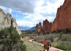
Garden of Gods, Colorado Springs
The Garden of Gods is a 1,300 acres free public park that grew around the original 480 acres land donated by a rail baron’s family in 1909. The park displays spectacular, vertical ‘fins’ of red and white sandstones and limestones (Photo 2), which were formed as a result of uplift associated with the formation of the Rocky Mountains (80 – 50 million years ago) and subsequent weathering and erosion. The park can be visited via an inner loop road alongside which are several parking areas and much of the beautiful rock exposure can be seen from walkways with easy climbing options.
Day 3: Drive across Colorado, visit Black Canyon of Gunnison National Park, stop at Blanding, Utah
Next day, our first destination was the Black Canyon of Gunnison National Park (BCGNP), 230 miles West of Colorado Springs. Colorado is a state of extraordinary natural beauty. We drove non-stop and crossed high mountains with snow-capped peaks; wide valleys with ranches and farmlands; mountain streams, lakes and canyons; and quaint little towns, and after four and half hours arrived at BCGNP.
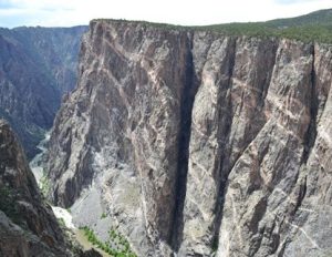
The BCGNP is one of the least visited (300,000+ annually) national parks in America because of its off-track location and a relatively small window of time for the best viewing of the canyon. The canyon wall is made of dark Gneissic rock and the Gunnison River lies at the bottom of a narrow and steep canyon where light can only shine if the sun is overhead. We drove along the South rim of the canyon for about an hour and stopped at several lookout points and took photographs
Black Canyon of Gunnison State Park, Colorado showing dark canyon walls with white Granite fissures and Gunnison River
Our final destination for the day was the small town of Blanding (pop. 3,300) 250 miles away in East Central Utah where we had reserved an Airbnb home for four nights. The town was a suitable launching point for various trips that we had planned to take. From BCGNP, we drove North on UT 50 and took IS 70 West from Grand Junction to enter Utah and then turned south on Route 191.
Utah, although the adjacent state to Colorado, is quite different in geology, landforms and climate. Elevation drops dramatically from the high peaks of Colorado onto the flatter terrains of Eastern Utah. It is an extension of the Colorado Plateau, a red rock country deeply dissected into mesas, buttes, towering cliffs, pinnacles, spires and wide valleys and deep canyons with sparse rainfall to qualify as a desert. Utah also has the so-called ‘Big Five’ elite national parks (Arches, Canyonlands, Capitol Reef, Zion and Bryce Canyon) of the US. Route 191 went through Moab, the hub of mountaineering and river rafting activities in Eastern Utah and after another hundred miles’ drive we reached Blanding.
Day 4: Arches National Park, Utah
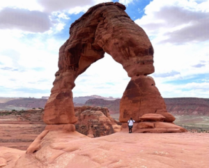 The Delicate Arch, Arches National Park, Utah’s state symbol
We headed back North on 191, passed Moab and drove up the steep ramp to enter the Arches National Park (ANP). It is a relatively small (119 sq. miles), but popular park (1.5 million visitors every year) and known for more than 2,000 recorded arches of various sizes, pinnacles, balanced rocks, etc. Arches are results of dissolution and weathering along cracks in rocks which widened and transformed into arches over long geologic times. There are arches all over Utah and adjacent states, but in ANP they are concentrated in large numbers. At peak season, entry time in this park is strictly regulated. Our online reservation gave us 6 hours, which was enough for us to stop at fifteen viewing points needing relatively short walks. Longer hikes are necessary to see some of the remote arches. My son hiked the 4 km round trip to reach the famous Delicate Arch (Photo 4) which I had done years ago in 1998.
Day 5: Canyonlands National Park ‘Island in the Sky’ District
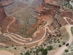 View of an unpaved road lacing down to the canyon floor from ‘Island in the Sky’, Canyonlands NP
The Canyonlands National Park (CNP) is the largest NP in Utah (337, 508 acres, about a million visitors per year) and the only one that none of us had visited before. The Park is split into three major districts – Island in the Sky, The Needles and The Maze – split by the Colorado and Green rivers and unconnected by paved road. On this day, we drove about 140 miles north on 191/UT 313 from Blanding to visit the Island in the Sky, the most popular of the three sections. This section is a huge mesa about 1000 ft above the canyon floor, hence the name ‘Island in the Sky’, and a 34 miles round trip drive on the mesa top takes visitors to many overlooks (Photo 5), generally within short walking distance from the parking spots. Many trailheads also originate at these stops from where additional points of interest can be reached by longer hikes.
Day 6: Canyonlands NP – The Needles District, Newspaper Rock
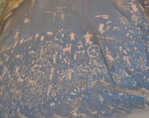 Newspaper Rock. A petroglyph panel used by Native Americans for over 2000 years. On the way to the Needles District, Canyonlands NP
The entrance to the Needles District is closer to Blanding, only 70 miles. We took the UT 211W from 191 and on the way to the Needles stopped at an interesting site called the Newspaper Rock State Historical Monument. Under a roadside rock overhang are numerous petroglyphs chiseled on a smooth rock face that researchers say were made by Native Americans over a period of 2,000 years (Photo 6). It was as if someone made a petroglyph when a new idea or a new information, like a newspaper report, came to him.
UT 211 is a scenic drive parallel to the Indian Creek flowing over a broad valley bound by flat-topped mesas and canyons. Within the park, there are relatively few roadside stops, and compared to the Island in the Sky district, the geologic features you see here are less impressive. To see the famous sites of The Needles, such as the Confluence of Colorado and Green rivers Overlook, or aggregates of sandstone spires that give the district its name, long hikes (10 miles or longer round trip) or 4WD on dirt roads are required.
Day 7: Gooseneck State Park, Forrest Gump Point, and Monument Valley
On this day, we left Blanding and drove south on UT 191 instead of north. A few miles down, we took the famed Route 163 to take us to Monument Valley. But, first, we took a detour via 261/316 to visit the Gooseneck State Park (GSP). The GSP is known for the spectacular ‘entrenched’ meander bends carved out by the San Juan River over millions of years as the land was uplifted, entrenching the river’s meanders within 1000 ft tall cliffs (Photo 7).
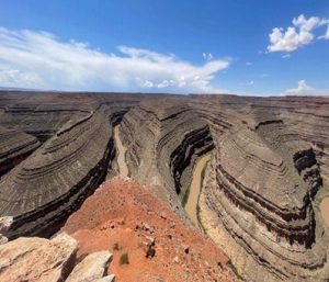 Meander bends of San Juan River. Gooseneck State Park, Utah
As we approached the Monument Valley, high red rock formations, mesas, buttes and volcanic plugs started appearing. When I went this way last, the Forest Gump Point was yet to be a big deal, but now it is a must stop for visitors. We stopped amid many other cars in a roadside parking area (Fig 8) and took some pictures of the road where Forrest Gump finally stopped running in the movie. Twelve miles later, we were at the visitors’ center of Monument Valley.
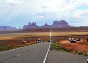 Forrest Gump point on Route 163 going south toward Monument Valley
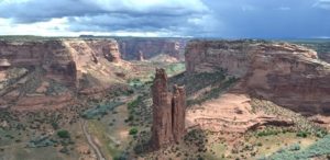
The Monument Valley straddling the boundary between Utah and Arizona is managed by the Navajo Tribe’s Parks and Recreation Department and is called Oljato – Monument valley. It is one of the most iconic natural monuments in America and sacred to the Navajos. The unique landscape, dominated by colossal red sandstone buttes and spires (Photo 9), have been featured in more than 50 films, notably movie classics directed by John Ford and acted by John Wayne, and in numerous TV shows, video games, music videos and album covers.
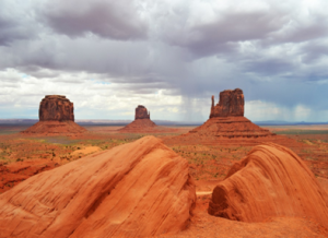 Monument Valley with clouds hovering overhead. Navajo Tribal land
From Monument Valley, we drove south for an hour and half on 163/59 S through Arizona to reach the town of Chinle where we spent the night in a motel. The next and last item on our list – the Canyon De Chelly National Monument was just outside the town.
Day 8: Canyon de Chelly National Monument
The Canyon De Chelly (pronounced ‘de Shay’) is a vast park in NE Arizona administered by the Navajo Nation jointly with NPS. From the visitors’ center we first drove along the North Rim Drive (flanking Canyon Del Muerto), came back, and then drove on the South Rim Drive (along Canyon De Chelly and Monument Canyon), stopping at ten overlooks and peering down on to the valley floor and across the canyons.
The beautiful canyons with sheer walls and verdant floors with rivers, trees, green pastures and farms and scattered Indian ruins (Photo 10) are definitely a pleasure for the eyes, but the human history of these canyons is also marked by the struggle of Navajo people, first against Spanish colonists and later against the US government forces. These canyons have been continuously inhabited by Native American tribes for 5,000 years, as seen in numerous cliffside pueblo ruins, and some forty Navajo families still call it home. Jeep tours with Navajo guides are also available for visiting the canyon floor homes and ruins.
 Canyon De Chelly National Monument, Navajo Tribal land, NE Arizona showing the Canyon Floor below and the 800 ft tall Spider Rock, a sacred rock in Navajo lore.
Day 9: The return
From Canyon De Chelly, we drove 400 miles, first South on 191 and then east on 264/IS40 through New Mexico and spent the night in Tucumcari, a storied town on historic Route 66. Next day, we drove another 750 miles through Amarillo (Photo 1) to reach Dallas in the evening. Overall, it was a wonderful road trip.
Golam Sarwar has a Ph.D. in Geology from the City University of New York (CUNY). He had taught as adjunct lecturer in Brooklyn College, Hunter College and College of Staten Island under the CUNY system and as assistant professor in Texas A & M at Commerce. In the later part of his career, he also worked in the IT industry in Dallas Morning News and other Dallas-based companies before retiring in 2021. He currently lives in Wales and enjoys traveling and writing about it.
Golam Sarwar
Golam Sarwar has a Ph.D. in Geology from the City University of New York (CUNY). He had taught as adjunct lecturer in Brooklyn College, Hunter College and College of Staten Island under the CUNY system and as assistant professor in Texas A & M at Commerce. In the later part of his career, he also worked in the IT industry in Dallas Morning News and other Dallas-based companies before retiring in 2021. He currently lives in Wales and enjoys traveling and writing about it.


